
This page sets out that address, the coordinate we publish and exactly what it is, the road the site takes its access from, and every distance we hold — all of it road distance, none of it straight-line. It also corrects two things the pre-launch material in circulation got wrong about this location, both of which have practical consequences for a buyer: the local authority, and the pin on the map. Inside the Bengaluru search area, Urbanrise Whitefield helps buyers keep the map conversation grounded in actual routines instead of only distance claims.
The address on the environmental filing
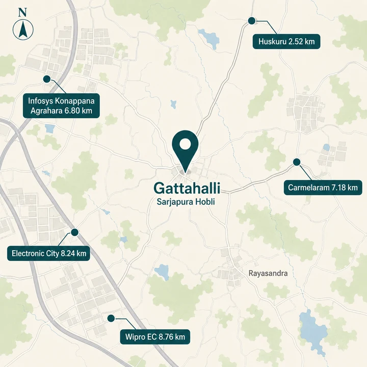 Gattahalli, Sarjapura Hobli — routed road distances — Urbanrise Gattahalli
 The promoter's fresh environmental clearance application, filed with the state environmental authority, records the site as follows.
| Field | As recorded on the filing |
|---|---|
| Survey number | Sy. No. 50 |
| Village | Gattahalli (free text) · GHATTIHALLI under structured village code 613187 |
| Hobli | Sarjapura |
| Taluk | Anekal |
| District | Bengaluru Urban |
| Promoter of record | Alliance Grandeur Homes Private Limited |
| Status | Under verification, filed 7 July 2026 |
| Land | 1.6996 ha = 4.20 acres |
That is the whole of the verified address. It is a survey-number address in a revenue village, which is what pre-launch land in this belt normally has, and it is more specific than the locality names that marketing material tends to use.
Gattahalli and Ghattihalli are one village, not two
The two spellings appear on the same record. The government's plot entry pairs the free-text description "Sy. No. 50, Gattahalli Village, Sarjapura Hobli, Anekal Taluk" with structured village code 613187, which resolves to GHATTIHALLI, on the identical plot. The pre-launch material in circulation raised the possibility that these were two different villages and that the project might be in the wrong one. They are not two villages. It is one place with two transliterations of the same Kannada name, and the filing uses both without contradiction.
We use Gattahalli throughout this site, because that is the spelling on the filing and in the address. If you search land records, khata extracts or encumbrance certificates and find Ghattihalli, that is the same village.
What the filing does not record
The application does not carry a pincode for the site. The postal address printed on the application is the promoter's Bengaluru corporate office, not the project's address, and we do not republish a corporate pincode as if it were the site's. A pincode matters — it is what a bank, a school admission form and a courier will ask for — so the honest position is that this one is not yet established in any published document, and a buyer should take it from the khata or the sale deed rather than from any website, ours included.
Nor does the filing record a street address, a project road name, or a ward. Below the taluk level, the only fixed identifier this project currently has is the survey number.
The coordinate for Sy. No. 50, and what it actually is
We publish 12.87146, 77.70101.
That number is an estimate, and it is worth being exact about how it was derived. The promoter submitted a site-boundary file with the application. The corners of that boundary box are 12.87059, 77.70020 and 12.87233, 77.70183 — an extent of roughly 193 m by 176 m. Those corners are verified: they come from the promoter's own uploaded file. The single point we publish is the centre of that box, which is our arithmetic, not the government's. A bounding box is always at least as large as the land inside it, and 193 by 176 metres is the right order of size to contain a 4.20-acre parcel.
Two things raise our confidence in that centre. The filed site boundary carries the project name, which ties the geometry to the developer rather than to a generic template. And the Plus Code carried in the material in circulation, VPC2+CGM, falls 52 metres from the box centre — close enough to be independent corroboration of the same parcel.
Confidence: medium-high. It is a derived centroid of a verified boundary, not a surveyed corner peg. Treat it as "this parcel", not as "this doorstep".
The pin in the material in circulation is wrong, and it mattered
The latitude and longitude supplied in the material in circulation do not point at this site. They fall roughly 1,216 metres away, over towards Rayasandra. We have discarded that coordinate and it appears nowhere on this site.
That is not a pedantic correction. Every proximity claim the brief made was computed from the wrong pin, and at least one of them was badly distorted by it: the brief placed the nearest project we already cover, TVS Emerald's development at Rayasandra, a few hundred metres from this site. From the corrected centre the straight-line separation is about 1.52 km, several times that material's figure. Any short proximity figure you may have seen for that pair in circulating material is an artifact of a bad pin, and we do not repeat it. We give 1.52 km here only as a bearing for orientation. It is a map separation, not a drive.
The road Urbanrise Gattahalli takes its access from
The pre-launch material in circulation states that access is direct from Gattahalli Main Road, and describes that road as 9 metres wide. The road name and the width both come from the brief, not from the filing, so treat the width as an unconfirmed marketing figure rather than a specification. We publish it anyway, because it is exactly the kind of detail a buyer needs and it would be easy to leave out.
No source we hold places this site on a named arterial. It does not front Sarjapur Road. It does not front Hosur Road. The Yellow Line metro corridor and the Hosur Road employment spine both lie some kilometres to the west. What the site fronts, on the only description available, is a village main road.
Nine metres is a two-lane village road with no service lane and no formal footpath. For 368 homes on 4.20 acres — the unit count and the land area are both verified on the filing — that single access is the most important physical question about this location, and it is a question a buyer should put directly to the developer:
- Is Gattahalli Main Road proposed for widening, and by whom, and to what width?
- Where will the entry and exit gates sit, and how will they interact with morning traffic on that road?
- What is the internal circulation for a 2BF + GF + 18UF tower stack, and how does basement traffic reach the main road?
None of those have documented answers today. The environmental application is still under verification, and no traffic or road-widening commitment appears in anything we have seen. That is a gap, and we would rather name it than paper over it.
Jurisdiction: this is an Anekal parcel, not a city-corporation one
The pre-launch material in circulation names BBMP as the local authority for this project. That is wrong, and the error changes what a buyer should expect on khata and on property tax.
We tested the corrected site centroid against the official Greater Bengaluru Authority boundary — a single polygon of 2,990 vertices — and against the five-corporation boundary set. The site falls outside both. The test self-validates: MG Road, Whitefield/ITPL and Kudlu all test inside the same polygon, so the method is not simply returning "outside" for everything.
The site tests outside the Greater Bengaluru Authority boundary, about 2.8 km east of its nearest edge, placing it in the BMRDA planning region under Anekal jurisdiction. Buyers should expect panchayat khata and panchayat property tax rather than BBMP A-khata, and should confirm the khata classification on the specific survey number before purchase.
Two honest qualifications belong beside that.
First, 2.8 km is a thin margin, not a wilderness. Anyone reading "outside the city boundary" as "far outside" is reading it wrong. The urban edge is close, and the corridor between here and it is actively building out.
Second, the boundary is politically live. BBMP was dissolved into the Greater Bengaluru Authority on 2 September 2025, and the reorganisation of Bengaluru's local government is recent enough that boundaries and jurisdictions may be revisited. What we can say is what the current official boundary shows. What we cannot say is what it will show in five years, and no honest page should pretend otherwise.
Practically, taluk and district are not administrative trivia. Anekal taluk determines which sub-registrar's office the sale deed goes to, which planning authority the layout answers to, which body issues the khata, and which body collects the tax. A buyer who assumes a city-corporation A-khata on this parcel and later discovers a panchayat khata has a resale and a home-loan conversation ahead of them. Verify it on the survey number, in writing, before any payment.
Employment within reach of Gattahalli
Every figure below is road distance from the routed table, computed from the corrected pin on the public road network. We publish kilometres and not minutes; the reason is set out further down.
The site's employment case rests on the Electronic City and Hosur Road corridor to its west, plus the Sarjapur-side tech parks to its north.
Within about 6 km by road
| Destination | Road distance |
|---|---|
| CBR Convention Centre | 5.15 km |
| Discovate Studios | 5.27 km |
| TCS Think Campus | 5.65 km |
| Wipro SEZ | 5.65 km |
| Sattva South Avenue | 5.70 km |
| Salarpuria Sattva Alexandria Tech Park | 5.71 km |
| Tech Mahindra | 5.79 km |
| Wuerth India Pvt. Ltd. | 5.84 km |
| D-Link India | 5.91 km |
| TATA BP Solar | 6.01 km |
Between about 6 and 10 km by road
| Destination | Road distance |
|---|---|
| Tech 37 | 6.04 km |
| Hical Magnetics Pvt Ltd | 6.64 km |
| Wipro Corporate Office | 6.71 km |
| Maruthi Concorde Tech Park | 6.73 km |
| Infosys Foundation, Konappana Agrahara | 6.80 km |
| Sattva Spectrum | 7.07 km |
| Center for Development of Telematics | 7.09 km |
| HCL Technologies | 7.34 km |
| Wipro SJP2 | 7.35 km |
| Tejas Networks Ltd | 7.52 km |
| ITI Spacenet | 7.65 km |
| Fanuc | 7.69 km |
| Prestige Trinity Center | 7.88 km |
| Zepto HQ-Bharat IT Park | 7.94 km |
| RGA Tech Park | 7.96 km |
| Siemens | 7.99 km |
| Titan | 8.01 km |
| Electronic City | 8.24 km |
| BHEL | 8.27 km |
| 3M | 8.30 km |
| C-DAC | 8.31 km |
| Biocon Hebbagodi | 9.59 km |
The shape of that list is the useful part. There is no single dominant employer at two kilometres. Instead there is a long spread of recognisable workplaces across a band running from about five to ten kilometres, most of them reached along the same westward roads. For a household with two earners working in different parks along that corridor, the spread is an advantage. For a household hoping to walk or cycle to work, it is not a walkable location by any reading of this table.
Rail and metro from Gattahalli
| Node | Road distance |
|---|---|
| Huskuru | 2.52 km |
| Carmelaram railway station | 7.18 km |
| Hosa Road | 7.20 km |
| Delta Electronics Bommasandra (Namma Metro, Yellow Line) | 7.96 km |
| Huskur Road | 8.09 km |
| Beratena Agrahara | 8.16 km |
| Wipro EC Bus Stand | 8.76 km |
Huskuru at 2.52 km is the nearest node on the routed transit list and the closest thing this site has to a local transit anchor. Carmelaram is the nearest suburban railway station in the table at 7.18 km by road.
The metro connection is real, and it is about eight kilometres away
Namma Metro's Yellow Line is operational. It was inaugurated on 10 August 2025 and began carrying passengers on 11 August 2025, running from RV Road to Delta Electronics Bommasandra — 16 stations over 19.15 km.
Delta Electronics Bommasandra is 7.96 km from this site by road. That is a running metro connection with trains on it today, not a proposal, not an alignment on a plan, and it is the single strongest connectivity fact this location has.
It is also, plainly, a drive. Eight kilometres to a station is a car, an auto or a feeder bus at each end — it is not a walk, and this site is not metro-adjacent. The Yellow Line runs along the Hosur Road corridor well to the west of Gattahalli. The honest framing is the one we use throughout: the nearest operational metro station is about eight kilometres away by road.
We publish no Metro Phase 3A station or distance for this site. No alignment has been published, and a station drawn from an unpublished alignment is worth nothing to a buyer committing several crore rupees.
Schools and colleges near Sy. No. 50
Schools are the strongest short-distance category in this table — the only category with several credible entries inside three kilometres.
| School | Road distance |
|---|---|
| Edenbridge International School | 1.55 km |
| Prakriya Green Wisdom School | 2.30 km |
| Primus Public School | 2.59 km |
| Amrita International Vidyalayam | 3.73 km |
| IGNOU Regional Centre | 4.11 km |
| Notre Dame Academy | 4.22 km |
| Harvest International School | 4.23 km |
| Brookfield High School | 4.29 km |
| Ebenezer International School Bangalore | 4.37 km |
| St Gasper School | 4.54 km |
| GIG International School | 4.92 km |
| Head Start Educational Academy | 5.19 km |
| Glentree Academy | 5.20 km |
| Delhi Public School Bangalore East | 5.55 km |
| NPS East, Sarjapur | 5.70 km |
| Bethany High Sarjapur | 5.72 km |
| Kunskapsskolan Bengaluru | 6.04 km |
| Silicon Valley School, Konappana Agrahara | 6.35 km |
| National Public School, Hosur Road | 6.71 km |
Higher education sits at a similar remove.
| Institution | Road distance |
|---|---|
| Bangalore Technological Institute | 2.34 km |
| Bhoomi College | 2.38 km |
| Vidya Shri College | 3.10 km |
| Florence Institutions | 4.65 km |
| National School of Business | 5.05 km |
| Xavier Institute of Management and Entrepreneurship | 5.82 km |
| Suvidya College | 6.17 km |
| SFS Degree College | 6.19 km |
| PESU Electronic City Campus | 6.88 km |
| Symbiosis Institute of Business Management | 7.81 km |
| International Institute of Information Technology Bangalore | 8.45 km |
| IFIM Business School | 8.65 km |
| Krupanidhi Institutions | 10.22 km |
Three schools inside 2.6 km by road is a genuine result for a village-edge parcel, and it is the clearest everyday advantage this location offers. Note one trap in the list: Harvest International School is far closer on a map than on the road — the drive is nearly two and a half times the map separation, and 4.23 km is the number that governs a school run.
Healthcare around Gattahalli
| Facility | Road distance |
|---|---|
| Punarjani Ayurvedic Multispeciality Hospital | 3.65 km |
| JJ Hospitals | 5.48 km |
| JJ Hospital | 5.62 km |
| Vimalaya Hospital | 5.80 km |
| Blossom Hospital | 6.05 km |
| PESU Hospital | 6.07 km |
| Sacred Oak | 6.16 km |
| Sri Sai Hospital | 6.68 km |
| Apollo Cradle & Children's Hospital | 6.84 km |
| Apollo Clinic | 7.00 km |
| BN Specialty Hospital | 7.13 km |
| Stanford Speciality Hospital | 7.21 km |
| Hospitec Multispeciality Hospital | 8.79 km |
| Best E City Hospital | 8.88 km |
| Kauvery Hospital | 8.98 km |
| Motherhood | 9.30 km |
This is the category where the location is weakest, and it should be read carefully. The nearest entry of any kind is a single ayurvedic multispeciality hospital at 3.65 km. The larger, more familiar names — the Apollo units, Kauvery, Motherhood — sit between about 6.8 and 9.3 km by road. For a routine consultation that is unremarkable. For an emergency at night, the honest description is that there is no large tertiary hospital within a few minutes of this site, and a household with an elderly member or a chronic condition should weigh that specifically rather than accept a general assurance that "hospitals are nearby".
Retail, lakes and everyday needs around Gattahalli
| Destination | Road distance |
|---|---|
| M5 ECity Mall | 6.36 km |
| PNR Felicity | 8.35 km |
| CSK Mall | 10.67 km |
| Huskur Lake | 2.67 km |
| Gattahalli Lake | 3.13 km |
| Halanayakanahalli Lake | 4.35 km |
| Rayasandra Lake | 5.37 km |
| Kodathi Kere | 6.37 km |
Organised retail is a drive. The nearest mall in the routed table, M5 ECity Mall, is 6.36 km by road, and the next two are further still.
Everyday retail is harder to characterise honestly. The routed table is built from live public mapping records records, and the nearest generic convenience entry it carries — logged simply as petty shops and a medical store — is 7.42 km away. That does not mean there is no shop near the site. Village retail is chronically under-mapped in public mapping records, so this is a coverage gap in the data, not proven absence on the ground. What it does mean is that we have no documented evidence of organised daily-needs retail close to the parcel, and a buyer should walk the immediate surroundings before assuming a supermarket run is a short one.
Gattahalli Lake at 3.13 km deserves a note of its own. It is close on a map and much further on a road — the drive is 2.71 times the map separation, one of the sharpest divergences in the whole table. It is a name that will appear in marketing material as a nearby amenity. Three kilometres of driving is the real figure.
Why the map understates the drive from Gattahalli
This is a genuine finding about the location and not a technicality.
Across the ten transit destinations in the routed table, every single one has a road distance more than 1.3 times its straight-line separation, and five exceed 1.7 times. Electronic City is the sharpest of them: the road distance is 1.88 times the map separation, so the drive is very nearly double what a map ruler suggests. Carmelaram station is 1.78 times. Biocon Hebbagodi is 1.85 times. Huskur Road is 1.83 times. In the workplace list, RGA Tech Park is 2.38 times, and Hical Magnetics is 2.00 times.
The cause is structural. The site sits off the arterial grid, on a village road, with lakes, tank bunds and unconnected layout roads between it and the corridor to the west. There is no straight route from here to most places; there is a loop out to a main road and back in. Any distance you have seen quoted for this project that looks noticeably shorter than the figures on this page was almost certainly measured in a straight line, and possibly from the wrong pin as well.
This is also why we publish kilometres and not minutes. A single drive-time number for this corridor is close to meaningless — the same eight kilometres can be a twelve-minute run on a Sunday morning and something quite different on a weekday at nine. We would rather give you a road distance you can trust and let you judge the traffic than publish a confident minute count that will be wrong most of the time.
What the Gattahalli location asks a buyer to accept
A location page that only lists what is near is a brochure. Here is the other side.
It is dense for the site area. The filing records 368 residential units on 4.20 acres. That works out to 368 ÷ 4.20 = 87.6 homes per acre — our own arithmetic, and an estimate of density rather than a figure from any document. The filed built-up area of 79,634.39 sq m against a land area of 1.6996 ha, which is 16,996 sq m, is a ratio of about 4.7 to 1 (79,634.39 ÷ 16,996 = 4.69). Read that ratio with care: built-up area on an environmental filing typically counts basements and service areas that a floor-area calculation would exclude. Either way, this is a compact, vertical scheme on a small parcel, not a low-rise one.
Against that, the amenity commitment on the filing is real. The application records a club house at 2BF + GF + 2UF — a dedicated multi-level amenity building. On a 4.20-acre site that is a meaningful allocation of ground, and it is a verified line on a government document rather than a marketing claim. Both facts are true at once: the scheme is dense, and it has committed a substantial structure to shared amenity.
One narrow road serves all of it. The 368 homes, their visitors and their service traffic reach the outside world through the access described in the brief as a nine-metre road. Nothing we hold documents a widening.
The city boundary is close but on the other side. Expect panchayat khata and panchayat property tax. Confirm the classification on Sy. No. 50 before you pay anything.
Nothing here is settled yet. The environmental application was filed on 7 July 2026 and is under verification. No environmental clearance has been granted, and the project is not registered with the Karnataka Real Estate Regulatory Authority. Under Section 3 of the Real Estate (Regulation and Development) Act 2016, a project in a registrable class cannot lawfully be advertised, marketed, booked or sold before registration is granted. This site is an information and enquiry resource for a scheme at the approvals stage — it is not a booking channel, and no one should be taking money against this address today.
What we still do not know about this location. There is no published site plan, so we cannot tell you where the towers sit within the parcel or which way the units face. There is no confirmed pincode. There is no traffic study, no road-widening commitment, no water or sewerage connection detail, and no announced marketing name. Every one of those is a legitimate question to put to the developer, and an answer in writing is worth more than any page on the internet, this one included.
Enquire about Urbanrise Gattahalli
Urbanrise Gattahalli is at the stage where the useful thing is information rather than a booking, because there is no lawful booking to make. Leave your details and we will tell you when the position changes — when a Karnataka RERA number is issued, when the environmental file moves, and when the developer publishes a price, a floor plate and an amenity schedule. The enquiry form asks for a name, phone number, email address and message; name and phone are required.
Send an EnquiryUrbanrise Gattahalli Location FAQs
What is the road access to the site like?
The brief states that access is direct from the 9 m Gattahalli Main Road. We attribute the width to the brief rather than assert it, because no filing we have seen states a road width. We are not going to skip past the point, though. Nine metres is a narrow feeder for 368 homes served off two basement levels, and access-road width is one of the details that determines whether an estate feels workable or permanently congested at its gate. Ask what road widening, if any, is proposed, whether it appears in a sanctioned plan, and who is responsible for it. Drive the approach yourself in the evening peak.
Is it Gattahalli or Ghattihalli?
Both, and they are one village, not two. The government's own plot record pairs the free-text address "Sy. No. 50, Gattahalli Village, Sarjapura Hobli, Anekal Taluk" with the structured village code 613187, which resolves to GHATTIHALLI, on the identical plot. So the two spellings are the same place, and material that treats them as two different villages has misread the record. We use Gattahalli throughout this site because that is the spelling on the filing and in the address. If you are searching land records or portal listings and one spelling returns nothing, try the other before concluding the record does not exist.
Which schools and colleges are closest?
Edenbridge International School is the nearest at 1.55 km by road, followed by Prakriya Green Wisdom School at 2.30 km and Primus Public School at 2.59 km. For higher education, Bangalore Technological Institute is 2.34 km and Bhoomi College 2.38 km. One worked example of why we insist on road distance: Harvest International School is only 1.73 km away on a map but 4.23 km by road, a detour factor of nearly 2.5, because the direct line crosses land the road network does not. A school that looks close on a map can be a materially longer school-run in practice. Check the actual route, at the actual hour.
What do apartments on this corridor actually sell for?
The nearest developer-published rates we can cite belong to a different builder. Modern Spaaces publishes rates on its own site for several Sarjapur-corridor apartment projects, ranging from about Rs 6,473 per sq ft at the lower end to about Rs 9,241 per sq ft at the upper end across five projects, read on 27 August 2026. Those projects sit roughly 5 to 10 km away and are another developer's product, so they are corridor context, not comparables for an Urbanrise scheme. Urbanrise operates as a volume developer, so a rate read borrowed from a boutique developer's premium product would mislead in one direction, and we decline to convert that band into an estimate for this project.
What is the exact address of the project?
The address on the filing is Sy. No. 50, Gattahalli Village, Sarjapura Hobli, Anekal Taluk, Bengaluru Urban District. That survey number is the single most useful string a buyer has, because it is what an advocate searches for encumbrance, title and khata records, and it is what any sanction or registration must eventually attach to. Note the taluk: Anekal, not Bengaluru South or Bengaluru East. Postal descriptions in marketing material tend to drift towards better-known names on the Sarjapur Road corridor, so check that any document you are handed carries this survey number and this village.